Main content
Recent lithium exploration on the Eagle Mountain claims resulted in the definition of several high priorities that warrant further work. Analyses of 61 shallow auger holes indicate that the 12 square kilometre area of the playa is anomalous in lithium with values of up to 240 ppm.
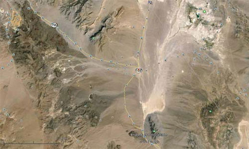
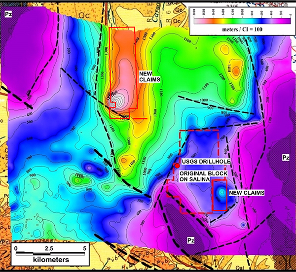
The gravity survey has identified several first-order structural features (Figure 3) similar to the Clayton Valley Basin that have potential to host lithium-rich brines. These include a north-south trending paleo-channel, a sub-basin underlying the southeast portion of the property, and sediments dipping west towards a major structure bounding the northeast side of Eagle Mountain. A recently staked fourth target, is a prominent basin feature, a gravity low target, located within the Amargosa Basin, about 7 kilometres northwest of the original Eagle Mountain Property. It extends over a north-south length of about 10 kilometres, comparable in scale to the mapped trend at Clayton Valley, suggesting potential for a significant lithium brine resource.
The next phase of work is expected to include a CSAMT geophysical survey to define drill targets. The property is readily accessible and located directly along the trend of target basins between Clayton Valley, Bonnie Claire, and Death Valley which are recognized by the USGS and exploration companies as priority environments for lithium brine concentrations.
Location
The property referred to herein as the Eagle Mountain claims consists of 248 placer claims, containing 31 blocks of 8 claims each. It measures approximately 8 km N-S by 4 km E-W and covers 4,960 acres. The land parcel has recently been expanded by staking of an additional 3460 acres of claims (24 parcels of 20-acre claims) based on encouraging phase 1 geochemical data and new targets mapped by a detailed gravity survey. The claims are located 10km SSE of Death Valley Junction in Inyo County, California, within 15km of the Nevada border. They cover most of the Eagle Mountain Salina found within the Alkali Flats area. All are on BLM land within the Mojave Desert and are located some 200km SE of Albemarle's Silver Peak Lithium Mine at Clayton Valley, Nevada, the only lithium producing mine in North America.
Previous Work
The western and central parts of the salina were periodically held and explored for their contained borate minerals between 1880 and 1930.
The United States Geological Survey (USGS) reported sampling and drilling in closed basins throughout portions of Nevada, primarily in and around the Clayton Valley region, and adjacent California. USGS Open-File Report 80-1234, 1980 especially targets 23 playas in the Mojave Desert of southeast California including the Alkali Flats area, which contains the claims. Their work at Alkali Flats consisted of taking bore-hole samples from a 102.1m deep hole located near the western margin of the claims area. Of the 68 bore-hole samples taken, 45 returned lithium values between 300 and 999 ppm, and 22 samples between 100 and 299 ppm. In addition, three brine samples were collected from this hole returning 0.07, 0.12 and 0.12 ppm lithium and 1,500, 1,000 and 1,100 ppm chlorine at 41.4, 71.6 and 102.1 meters depth, respectfully. No borate or potassium results were disclosed. The bore-hole rock sample results were the strongest anomalous values obtained by this USGS study of the 23 playas.
This survey is particularly important due to the quality of geochemical results published by the USGS in 1977 in the salina target area. The values from the solids in this 102.1-meter drill hole, which was part of a regional study of possible lithium salina targets throughout the Mojave Desert in California, were strongly anomalous with 45 of 68 samples in the range of 300 to 999 ppm (USGS OFR 80-1234). In a more detailed examination of this RC drill hole Pastea ( USGS OFR 86-1164) used both AA and emission spectra methods and conducted some mineralogical studies using the laboratories in Menlo Park, California, and Denver, Colorado. Using the AA the range of all samples was 58 to 810 ppm, and the four samples subjected to emission spectra returned values of 1100 ppm, 1100 ppm, 810 ppm and 1100 ppm lithium.
Conceptual Considerations
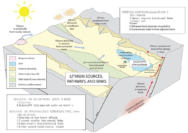
Of the major sources of lithium – brine, pegmatites and lithium clays – the brine deposits are dominant and are expected to maintain their dominance primarily due to the competitive cost of production; therefore our emphasis is on brine deposits.
The selection of the Eagle Mountain property was based on an assessment of the various known salars in the region primarily using the work by the USGC (D. Bradley, et al, 2013, A Preliminary Deposit Model for Lithium Brine and Munk et al, 2011, Final Technical Report: Lithium Brine Resources, A Predictive Exploration Model) as a conceptual model. This model is based on features believed to be favorable for localization of economic lithium deposits at Clayton Valley, which hosts the only North American producer (Albemarle’s Silver Peak Mine), and the large Chilean deposits from the Salar de Atacama in Chile.
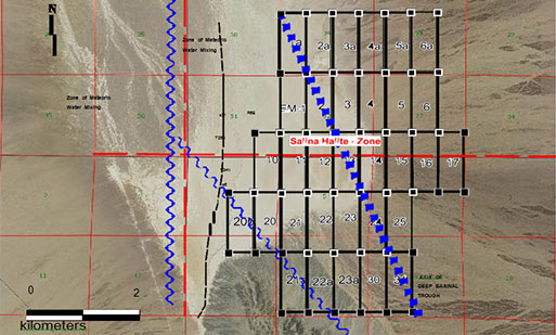
For reference, their schematic presentation is included herein (Figure 2). Their observation (C. Bradley et al, 2013, page 1) is noted that “All producing lithium brine deposits share a number of first-order characteristics: (1) arid climate; (2) closed basin containing a playa or salar; (3) tectonically driven subsidence; (4) associated igneous or geothermal activity; (5) suitable lithium source-rocks; (6) one or more adequate aquifers; and (7) sufficient time to concentrate the brine”. All these characteristics clearly apply to the Eagle Mountain property.
Results of Recent Work Program
Exploration work included a gravity survey and soil sampling covering the property. The objective of the gravity survey, completed in December 2016, was to generate a basin model as an aid to lithium exploration.
The survey also defined the regional structural setting revealing complex structures dominated by a major fault bounding Eagle Mountain on both sides. Several first-order structural features representing targets for more geophysical work were outlined by the survey. The gravity survey defined the southern portion of the Amargosa Basin, revealing a shelf extending to the south, off the main basin underlying the property. A major structural feature extends across the property in a northwest-southeast direction, bounding Eagle Mountain on either side. The structure forms the south-southwestern margin of the basin shelf. Gravity data suggests that the basin fill layering in the shelf may dip southwest toward the Eagle Mountain bounding structure. This asymmetry, similar to the Clayton Valley Basin, is interpreted to be an important control to lithium brine entrapment at the Clayton Valley deposit.
Three target areas on the Eagle Mountain property are defined based on similarities to the Clayton Valley deposit. These include the north-south oriented paleo-channel, a sub-basin underlying the southeastern portion of the property and sediments dipping west towards the major structure bounding the northeast side of Eagle Mountain (Figure 3).
A recently staked fourth target is a prominent basin feature with at least 700 meters of sediments and located within the Amargosa Basin, about 7 kilometres to the northwest of the original Eagle Mountain Property. It extends over a length of at least 10 kilometres in a north-south direction and represents an important exploration target.
A controlled source audio magneto-telluric (CSAMT) geophysical survey has been recommended by James L. Wright, consulting geophysicist and author of the gravity report. A CSAMT survey is well suited for delineation of basin fill bedding. In additional, brines are low resistivity and the survey can be used to target brine concentrations in basin fill.
In December 2016, a total of 61 soil samples from shallow, dry drill holes, were taken across the playa surface covering an area of about 15 square kilometres. The playa surface is covered by a crusty mix of halite, sodium chloride, borates, silt and clay. The sampling has revealed a 12 square kilometre area of lithium mineralization ranging up to 240 ppm.
The samples were processed by Chemex Labs in Reno, Nevada. The analytical range for lithium for the method used is 0.1ppm to 1%. The multi-element package subjects samples to aqua regia digestion followed by ICP-MS analysis. This method is suitable for early lithium exploration in sedimentary deposits.
Interpretation of the Structural Setting
A satellite image for the claims and surrounding area is presented in Figure 3A and 3B together with a synoptic interpretation of the structural setting. The salina lies within a north-south trending basin essentially closed to the south. This basin interacts at the western fringe with the Amargosa River Drainage which is recognized by the USGS as regionally enriched in lithium ( 18 springs and wells in the Amargosa Desert averaged 105 micrograms per liter lithium as compared to 2 micrograms per liter for the mean of 100 major municipal water supplies in the United States).
The central and eastern portions of the basin are bounded by a major north-south range-front fault to the east. This trap basin is further defined by the west-northwest Eagle Mountain Fault to the west that separates the main trap basin from what is interpreted to be a zone of shallow mixing and erosion of the borates and evaporates on the saline’s western fringe. It is within this zone that the USGS located their drill hole. The area which remains closed and a suitable trap for brines constitutes the vast majority of the property area.
Field relationships suggest that the salina was completely closed for an extended period of time, followed by a recent breach along the western fringe localizing the mixing zone, an area of dilution and scouring of the surface evaporItes. For this reason and to optimize the land holding costs the claim staking was focused on the most mature (least leached or contaminated by surface waters) and deeper traps mapped by the new gravity survey. A CSAMT survey will be very useful in mapping targets in the deeper newly discovered basins.
The new gravity low target, located to the northwest of the original claims, is comparable in scale to the mapped trend at Clayton Valley suggesting there is potential for a significant lithium brine resource.
Proposed Work Program
In order to systematically evaluate the potential of the property, the next phase of work would entail fill-in geochemical sampling and geological mapping of the property. Samples would be collected on a 200 by 200-meter grid spacing over the playa in order to confirm lithium enrichment and to identify any zoning that may be present. A controlled source audio magneto-telluric (CSMAT) survey would be contracted to provide information on the basin fill bedding and the location of potential conductive brine reservoirs.
Further work would be dependent on favorable results and is expected to entail ground seismic work and drilling.